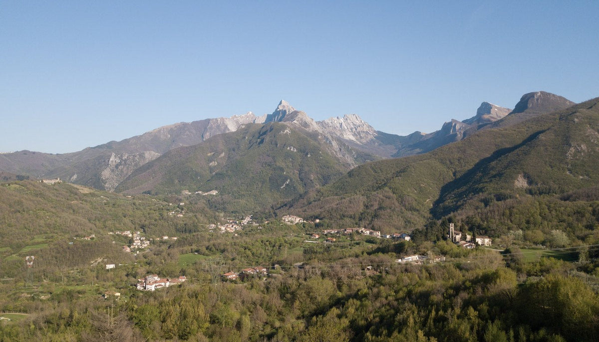
The Apuan Alps Regional Nature Park is a protected area covering roughly 20,000 hectares in northern Tuscany, spanning the provinces of Lucca and Massa-Carrara on the border with Liguria. Established in 1985, it is one of the most fascinating and biodiverse territories of the northern Apennines, with a landscape dominated by soaring peaks, karst caves, lush forests and medieval villages.
Despite their name, the Apuan Alps are not part of the Alps but of the Tuscan-Emilian Apennines, and owe their name to the height and grandeur of their peaks, comparable to those of the true Alps.
A recognized heritage
In 2016 the park was recognized as a UNESCO Global Geopark, in acknowledgment of its exceptional geological importance and extraordinary natural heritage.
History and origins
Geological roots
The Apuan Alps have ancient origins: they formed roughly 200 million years ago during the Triassic period, when the Tethys Sea covered much of present-day Europe. Tectonic movements and the thrust of the African plate gave rise to this mountain range, composed mainly of marble, a metamorphic rock that has made these mountains famous the world over.
Apuan marble, quarried since Roman times, has been used for masterpieces such as the Pantheon in Rome, Michelangelo's David, and the Cathedral of Santa Maria del Fiore in Florence.
People and the land
Traces of human presence date back to the Paleolithic, as shown by finds recovered from the area's caves. During the Iron Age, the Ligurian-Apuan peoples, from whom the mountains take their name, inhabited these lands, engaged in herding and farming. With the arrival of the Romans, the Apuan Alps became an important center of marble quarrying, an activity that continues to this day.
The birth of the park
The Apuan Alps Regional Nature Park was established under Regional Law No. 65 of 1985, with the goal of protecting biodiversity, preserving the geological and scenic heritage, promoting sustainable tourism, and showcasing local traditions.

Natural features
Geomorphology
The Apuan Alps present a unique and varied landscape. The highest peak is Monte Pisanino (1,946 m), followed by Monte Tambura (1,895 m) and Monte Cavallo (1,895 m). The area is also exceptionally rich in underground cavities and karst phenomena.
| Cave | Location | Features |
|---|---|---|
| Grotta del Vento | Fornovolasco | One of Italy's most famous show caves; a 4 km route among stalactites and stalagmites |
| Abisso di Malpasso | — | A depth of -1,089 m, among the deepest in Italy |
| Antro del Corchia | — | Italy's most extensive karst system: 70 km of tunnels and 1,200 m of vertical range |
Among the most spectacular sites are also the marble cliff faces and the Orrido di Botri gorge, a natural canyon carved by the Pelago river.
Flora
The park's vegetation is extraordinarily rich and varied, thanks to its distinctive geology and a climate ranging from Mediterranean to alpine.
| Habitat | Plant species | Features |
|---|---|---|
| Woodland | Beech, silver fir, chestnut, Turkey oak, downy oak | Centuries-old forests, some protected, such as Selva di Campocatino and Bosco di Malbacco |
| Grassland | Fescue, alpine clover, gentian, wild orchids | Open habitats above 1,500 m, rich in rare species |
| Rocky areas | Mountain pine, dwarf juniper, saxifrage, wormwood | Pioneer plants that colonize the rock faces |
| Wetlands | Black alder, willow, rushes, sphagnum moss | Peat bogs and marshy areas, such as Lake Vagli (artificial) |
| Endemics | Viola eugeniae, Cerastium apuanum, Saxifraga apuana | Species found exclusively in the Apuan Alps |
Fauna
The park is home to rich and diverse wildlife, including protected and rare species.
Mammals
- Apennine wolf (Canis lupus italicus)
- Wild boar, roe deer and fallow deer
- Mouflon, reintroduced in 1990
- Wildcat and badger
- Black squirrel (subspecies apuanus)
Birds
- Golden eagle, the symbol of the park
- Griffon vulture, currently being reintroduced
- Eagle owl and black woodpecker
- Rufous-tailed rock thrush
Reptiles, amphibians and insects
- Asp viper, slow worm, fire salamander, Italian tree frog
- The Apuan moth (Graellsia isabellae), a local endemic
- Rare beetles such as the violet ground beetle, Carabus violaceus apuanus
Tourism and farm stays
Where to stay
The park offers numerous accommodation options, from hotels and B&Bs in the main towns such as Castelnuovo di Garfagnana, Barga, Massa and Carrara, to mountain huts at altitude, to farm stays serving local produce.
| Property | Type | Location / altitude |
|---|---|---|
| Rifugio Donegani | Mountain hut | 1,580 m, on Monte Pisanino |
| Rifugio del Freo | Mountain hut | 1,700 m, in the Panie group |
| Rifugio Orto di Donna | Mountain hut | 1,380 m, overlooking the marble quarries |
| Agriturismo Il Colle | Farm stay | Gragnanella |
| Agriturismo La Capanna | Farm stay | Vagli Sotto |
| Agriturismo Il Casale delle Apuane | Farm stay | Minucciano |
Traditional cuisine
Local gastronomy is honest and deeply rooted in the land, with first courses based on chestnuts and spelt, mountain-pasture cheeses and cured meats aged in marble.
Dish
Description
Tordelli lucchesi
Ravioli filled with meat and chard
Castagnaccio
A cake made with chestnut flour
Neccio
A flatbread made with chestnut flour
Zuppa di farro
A soup with spelt, legumes and vegetables
Lardo di Colonnata
PGI-protected cured lard, aged in marble
Pecorino delle Apuane
A local sheep's milk cheese
Testaroli
A fresh pasta made with chestnut flour
Among the local wines, the Colline Lucchesi DOC, in both white and red, and the Candia dei Colli Apuani DOC, a white wine, stand out.
Local crafts
- Marble working: sculptures, flooring and decorative objects, with workshop visits available in Pietrasanta and Carrara
- Chestnut-wood products: baskets, furniture and utensils
- Ceramics: a well-established tradition in Barga and Castelnuovo di Garfagnana
Mountain biking: adventure on two wheels
The Apuan Alps are a paradise for mountain bikers, with technical trails, significant elevation gain and breathtaking scenery.
MTB areas
Garfagnana (north)
- Sentiero del Pisanino: a demanding route with steep climbs and technical descents (25 km, 1,500 m of ascent)
- Anello di Camporgiano: a 40 km loop through woods and medieval villages
- Valle del Serchio: a cycle path along the river, suitable for all levels
Versilia (south)
- Monte Matanna: a demanding climb with sea views (1,317 m)
- Sentiero delle Panie: a scenic route between Pania della Croce and Monte Procinto
- Piggy Track (Seravezza): an enduro track with jumps and technical turns
Aulella Valley (east)
- Anello di Fivizzano: a medium-length 30 km route through olive groves and chestnut woods
- Monte Sagro: a tough climb rewarded with 360° views over the Apuan Alps
Recommended routes
| Name | Length | Elevation | Difficulty | Points of interest |
|---|---|---|---|---|
| Pisanino MTB Trail | 25 km | +1,500 m | ★★★★★ | Summit of Pisanino, breathtaking views |
| Anello del Freo | 35 km | +1,200 m | ★★★★ | Rifugio del Freo, Panie della Croce |
| Matanna Enduro | 20 km | +1,000 m | ★★★★ | Technical descents, views over Versilia |
| Valle del Frigido | 15 km | +600 m | ★★ | Frigido waterfalls, shaded trails |
| Grotta del Vento | 12 km | +400 m | ★★ | Cave visit combined with a bike route |
Services for cyclists
Numerous bike rental points are available in Castelnuovo di Garfagnana, Pietrasanta and Massa, along with bike shuttle services to reach trailheads and repair workshops in Barga, Seravezza and Carrara. Highlights on the events calendar include the Apuane MTB Race, an annual endurance competition, and the Garfagnana Bike Festival.
Safety tips
Always carry a helmet, gloves, eyewear, a repair kit, water and food; check the weather forecast, since conditions can change quickly at altitude; honestly assess your own level on the more technical and exposed routes; respect the park's signage and stay on the marked trails.
Trails and hiking
The Apuan Alps Park offers more than 200 km of marked trails, suited to every need, from family walks to serious mountaineering challenges.
Mountaineering routes (EEA)
Normal Route to Monte Pisanino (1,946 m)
Starting from Rifugio Donegani (1,580 m), this route takes 3–4 hours round trip and is rated EEA, with rocky passages and fixed chains. The summit is marked by a metal cross with 360° views over the Apennines and the sea.
The Panie traverse
From Pania della Croce to Pania Secca and Pania di Corfino, starting from Passo della Focolaccia; the route takes 6–7 hours and is rated EE, with some exposed stretches. It takes in Pania della Croce (1,858 m) and Pania Secca (1,863 m).
Monte Tambura (1,895 m)
Starting from Fornovolasco, this route takes 5–6 hours round trip and is rated EE, passing Lago Santo and several rocky sections along the way.
Abisso di Malpasso (-1,089 m)
Accessible only with a caving guide, this route is rated as extremely demanding and requires specific technical equipment.
Intermediate hikes (E)
| Trail | Starting point | Duration | Highlights |
|---|---|---|---|
| CAI 13 — Monte Forato loop | Pruno (Stazzema) | 4–5 hours | The natural arch of Monte Forato, views over Versilia |
| CAI 7 — Donegani-Pisanino | Rifugio Donegani | 2–3 hours (one way) | Rocky sections |
| CAI 12 — Grotta del Vento-Corchia | Fornovolasco | 3–4 hours | Entrance to the cave, views over the marble quarries |
| CAI 1 — Alta Via delle Apuane | Cisa → Carpinelli | 120 km, 6 stages | Crosses all the park's main peaks |
Easy walks (T)
| Trail | Starting point | Duration | Highlights |
|---|---|---|---|
| Lake Vagli | Vagli Sotto | 1–2 hours | Artificial lake, the submerged village of Fabbriche di Vagli |
| Frigido waterfalls | Massa (Frigido area) | 1 hour | Natural waterfalls, lush vegetation |
| Sentiero dei Mulini | Barga | 2 hours | Old water mills, rural landscapes |
| Botanical trail | Abetone | 1 hour | Alpine plants, views over Garfagnana |
Maps and recommended apps
The CAI trail map is available at mountain huts, tourist offices and on the park's official website. Among the most useful apps are Komoot, with GPS tracks, Wikiloc, with user-shared routes, and Apuane Trekking, an app dedicated to the park.

Mountain huts and waypoints
| Hut | Altitude | Beds | Services |
|---|---|---|---|
| Rifugio Donegani | 1,580 m | 40 | Meals, overnight stays |
| Rifugio del Freo | 1,700 m | 30 | Meals, overnight stays |
| Rifugio Orto di Donna | 1,380 m | 25 | Meals, overnight stays |
| Rifugio Mariotti | 1,200 m | 20 | Overnight stays only (self-service) |
When to visit the park
| Season | Pros | Cons | Tips |
|---|---|---|---|
| Spring (April–June) | Mild temperatures, blooms, accessible trails | Possible rain | Ideal for hiking and mountain biking |
| Summer (July–August) | Long days, huts open | Heat at altitude, crowds | Hike at dawn or late afternoon |
| Autumn (September–October) | Autumn foliage, cool temperatures | Shorter days | Best season for MTB and hiking |
| Winter (November–March) | Snow at altitude, snowy landscapes | Closed trails, cold | Ski touring, for experts only |
How to reach the park
Main access points
- From Lucca (north): by car via SS 12 (Abetone-Brennero) to Castelnuovo di Garfagnana, about 1 hour; by bus, the CLAP line from Lucca to Castelnuovo di Garfagnana
- From Massa-Carrara (south): by car via SS 445 to Fornovolasco, about 40 minutes; by bus, the ATN line from Massa to Fornovolasco
- From Pistoia (east): by car via SS 66 (Pistoia-Abetone) to Abetone, about 1 hour
- From La Spezia (Liguria): by car via the A15 Cisa motorway to Fivizzano, about 1 hour
Main parking areas
- Passo della Cisa (northern access)
- Fornovolasco (southern access, near Grotta del Vento)
- Castelnuovo di Garfagnana (old-town car park)
- Vagli Sotto (lake car park)
Useful contacts
- Service
- Contact
- Apuan Alps Park Authority
- +39 0585 777521
- Emergency Room (Massa Hospital)
- 118
- Alpine Rescue (CNSAS)
- 112
- Castelnuovo di Garfagnana Tourist Office
- +39 0583 644650
- Massa Tourist Office
- +39 0585 490222
Further reading and resources
Recommended books
- «Alpi Apuane: Guida ai Sentieri» — CAI Lucca
- «Il Marmo delle Apuane» — Gianni Giannoni
- «Fauna delle Alpi Apuane» — Parco Naturale Regionale
Documentaries
- «Le Alpi Apuane: Il Cuore di Marmo» (RAI)
- «Apuane Selvagge» (National Geographic Italia)
Websites
- Apuan Alps Park (official website)
- CAI Lucca Section
- Apuane Trekking
Final tips and conclusion
Always carry
- Water, at least 1.5 liters per person
- A trail map or GPS device
- Layered clothing, since the weather can change quickly
- Hiking shoes with non-slip soles
Respect the environment
- Do not leave litter behind
- Do not collect plants or minerals, which are protected by park regulations
- Stay on marked trails to avoid damaging the flora
Plan ahead
- Check the weather forecast
- Verify trail accessibility, as some may be closed due to landslides or snow
- Book mountain huts in advance, especially in summer
The Apuan Alps Park is a natural gem offering adventure, relaxation and culture in a truly unique setting. Whether you are an experienced hiker, a mountain biking enthusiast, a geology lover, or simply seeking peace and beauty, this park is sure to deliver unforgettable experiences.
«The Apuan Alps are not just mountains: they are a journey through time, through marble, caves and villages that tell millennia-old stories.»
Article updated as of August 2026. Texts and images are for illustrative purposes. For official information, consult the website of the Apuan Alps Regional Nature Park.
Photo credits
- Cover: photo by RemaG, CC BY-SA 4.0, via Wikimedia Commons, cropped
- Image 1: photo by Ingo Mehling, CC BY-SA 4.0, via Wikimedia Commons
- Image 2: photo by Ravera Cristoforo, CC BY-SA 3.0, via Wikimedia Commons


